
Revived 1953 Map Helps Drive the Next Stage of the Withernsea Riff-Raff Project
A revived 1953 map of Withernsea, featuring more than 100 past and present landmarks, is set to play a major role in the next phase of the Withernsea Riff-Raff project.
Created by Darrin Stevens, chairman of the Friends of St Nicholas Church, alongside local historian Wendy Graves, the map has become the foundation of a growing heritage initiative designed to bring the town’s history back to life.
A project built on local pride
The name Riff-Raff is a deliberate nod to Withernsea’s past. Once used as a dismissive term for working-class visitors arriving by train, it has now been reclaimed and turned into something positive. A badge of pride that celebrates the people, stories and heritage of the area.
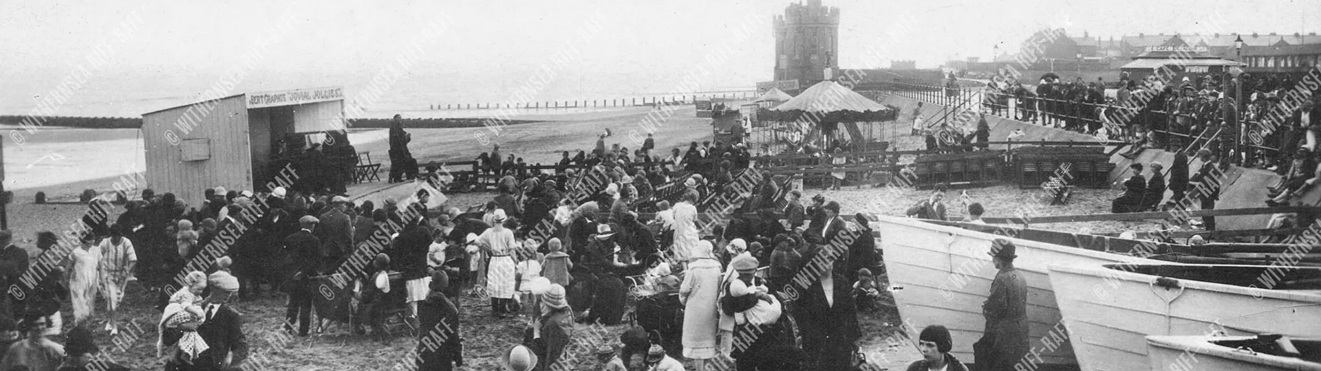
What began last year as a call-out to postcard collectors has quickly grown into something much bigger. The original aim was to build a digital archive of historic photographs and postcards from Withernsea and the surrounding area. Since then, the project has developed into what is believed to be the largest digital collection of Withernsea photographs ever assembled, with thousands of images gathered from across the town and nearby Holderness villages.
This remarkable archive has been made possible through the support of local contributors, including Peter McCurdy, John Broom, Anthony Ellis and many others who have shared their collections and memories.

Piecing together Withernsea’s history
Using the growing archive, Darrin has been able to uncover forgotten parts of Withernsea’s story and, for the first time, create photographic timelines for a number of locations around the town.
By bringing together material from different collections, the project is also able to show familiar places from multiple angles and perspectives. In many cases, even the handwritten notes and personal messages once written on the backs of postcards have helped restore stories that may otherwise have been lost.
More than 100 locations identified for QR heritage trail
The restored map has now helped identify over 100 locations that will form the basis of the project’s next stage.
QR codes will be placed at historic and present-day hotspots across Withernsea, allowing visitors and residents to scan them using their phones or tablets. Each location will open access to photographs, voice narration and interactive content linked to that specific place.
The aim is to make local history more accessible, more engaging and more immersive for everyone exploring the town.
Interactive walks, trails and rewards
The project will also introduce a series of themed walks around Withernsea, giving people the opportunity to follow trails connected to local history, heritage and community stories.
Participants will be able to work towards Bronze, Silver and Gold certificates, adding an extra layer of fun and discovery to the experience. Some walks will focus on historic postcard locations, while others will highlight the stories of notable Withernsea residents and community life through the years.
Alongside this, the new website, withernseariffraff.co.uk, is now live and available to explore.
Supporting tourism and regeneration
As well as preserving history, the project has a wider purpose. Data collected through QR scans will help show which areas of the town are being visited most often and which locations are proving most popular. This information could help shape future development and encourage visitors to explore more of Withernsea.
Local support for the project has continued to grow, with many people recognising its potential to boost interest in the town and encourage heritage-led tourism.
Funding so far has come from several local sources, including the disbanded Pier Project fund and Tesco Community Grants. The team has also submitted a £20,000 bid to the National Lottery to help expand the project further.
A labour of love
Speaking about the project, Darrin said:
“This project is about more than just postcards, it’s about regeneration. We want people to visit our area to see the heritage and history we have to offer.”
He added:
“This has been a labour of love for me, and Wendy Graves. We’ve put in over 3,000 hours of work.”
And perhaps most importantly:
“We are saving history. If these physical books or cards are ever lost, the digital record will remain.”
Wendy Graves also spoke about the effort behind the map and the hope for what it can bring to the town:
“The map has taken a long time to do and has been very painstaking. Hopefully it will bring people to Withernsea. It will be really fun.”
Wedding Through the Decades exhibition
Alongside the map and heritage trail work, the project is also behind a new Wedding Through the Decades exhibition at St Nicholas Church.
Taking place over the May bank holiday weekend, from Saturday 2 May to Monday 4 May, the exhibition will showcase wedding dresses, outfits and photographs from across the decades. It will be open daily from 11am to 4pm, and visitors will also be able to buy a cream tea in a box for £5.
People from across the region are invited to contribute wedding photographs, outfits and memorabilia from any era to be included in the display.
To take part, contact Darrin on 07956 386720.
Bringing history to life in Withernsea
The Withernsea Riff-Raff project is about far more than preserving old postcards. It is about giving people a new way to connect with the town, its landmarks and the stories that shaped it.
By blending archive material, interactive technology and community involvement, the project is creating something that honours the past while helping shape the future of Withernsea.
